Karakin Map
Explore the full Karakin map below. Guessing on Karakin isn't ready yet, but you can test your map knowledge on Erangel right now.

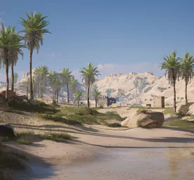

Karakin
2 × 2 km
Map size
In development
PUBGEOS game mode
Interactive Karakin map
Drag to move and zoom with the + and − buttons or Ctrl/⌘ + scroll. On touch screens use two fingers. Town and landmark names are part of the in-game map.
About the Karakin map
Karakin is PUBG's 2 × 2 km desert island, one of the smallest maps in the game. Rocky brown hills fill the middle, and the settlements sit near the coast.
With so little space, every named place is close to the next one. Use the interactive map above to see how the island fits together.
Key areas of Karakin
- Bahr Sahir – the north-west coast.
- Al Habar – the north-east.
- Bashara – the west coast.
- Hadiqa Nemo – the east side.
- Al Hayik – the south coast.
- Cargo Ship – the wreck off the south-west corner.
How to read the Karakin map
- Start from the coast. All the named places are close to it, so it's the quickest way to orient yourself.
- Use the Cargo Ship. It marks the south-west corner of the island.
- Remember the scale. On a 2 × 2 km map, short distances on the map are very short in the game.
